
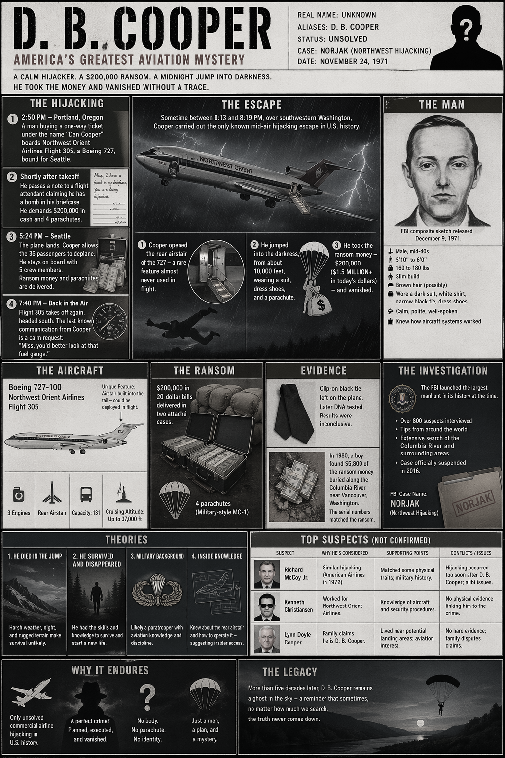
On November 24, 1971, a man traveling under the name Dan Cooper presented himself at Portland International Airport and purchased a one-way ticket for Northwest Orient Airlines Flight 305, bound for Seattle. He was described by crew members as composed, unremarkable in manner, and precise in his requests. He wore a dark business suit. A narrow black clip-on tie. He ordered a bourbon and water. He paid for his drink.
Shortly after takeoff, he passed a note to a flight attendant. The note stated that he had a bomb. When she returned, he opened his briefcase briefly — long enough to reveal what appeared to be red cylinders, wire, and a battery. His demands were specific: two hundred thousand dollars in unmarked twenty-dollar bills, four parachutes — two primary, two reserve — and a fuel truck waiting in Seattle. The four parachutes were not excess. By demanding more than he needed, he implied the possibility of a hostage, which prevented authorities from delivering a sabotaged chute. He had considered this.
The aircraft landed at Seattle-Tacoma Airport at approximately 5:39 p.m. By 7:40 p.m., he had the money. By 8:00 p.m., the passengers had been released. He ordered the plane refueled and airborne again, heading south toward Mexico City. He specified: altitude no higher than ten thousand feet, airspeed below one hundred fifty knots, landing gear down, flaps at fifteen degrees. These were not improvised conditions. They were parameters.
Somewhere over southwestern Washington, in darkness, in weather, he sent the remaining crew to the cockpit. The rear airstair of the Boeing 727 — a deployable feature accessible from the aircraft’s tail while in flight, unique among commercial aircraft then in service — was lowered. At approximately 8:13 p.m., the crew felt a shift in cabin pressure. When the aircraft landed in Reno, as instructed, Cooper was gone.
NORJAK · The Record as Left BehindWhat the Investigation Recovered
The Federal Bureau of Investigation opened the case under the designation NORJAK — Northwestern Hijacking — and it would remain formally active for forty-five years before being deprioritized in 2016. No arrest was ever made. What the investigation produced was a collection of fragments with no center.
Item 2: $5,800 in twenty-dollar bills. Recovered February 1980, Tena Bar, Columbia River. Serial numbers confirmed match. Condition: partial decomposition. No explanation for quantity, location, or condition has been established to the satisfaction of investigators.
Item 3: One parachute component (reserve chute, non-functional, deliberately packed non-deployable). Recovered in field, 1971. Suggests Cooper may have assessed his equipment.
Remaining $194,200: unrecovered.
The tie warrants particular attention. A man who left behind no confirmed identity left behind something that described a context: an industrial past, a working environment, a man who made things or worked adjacent to their making. The tie is not a clue in the conventional sense. It does not point anywhere. It is, rather, a residue — the kind of physical remainder that suggests the category of a person without specifying the individual.
The money at Tena Bar raises questions the river cannot answer. The site sits south and downstream of where most investigators have estimated the jump point to be. The bills were partially buried in a sand spit. Only $5,800 of the $200,000 arrived there. No further currency has ever been recovered anywhere. None of the prevailing theories fully accounts for why only a fraction appeared, why it appeared at Tena Bar specifically, or why it stopped.
Source document. Compiled from public record. Filed for reference. The FBI closed active investigation in 2016. No suspect was ever charged. No confirmed identity was ever established.
A Pattern of Constraints
There is no confirmed map. There was never a map.
What Cooper left behind was a sequence of decisions, and decisions — examined in order — describe a geometry. He chose a plane with a rear airstair: one of a small number of commercial aircraft offering a functional mid-flight exit. He chose a route passing over dense, unpopulated terrain: Cascade foothills, river drainage, timber country. He chose night. He chose weather. He specified a flight envelope that kept the aircraft slow enough for a survivable exit but fast enough to maintain altitude. He requested four parachutes, not two. He instructed the crew to stay forward.
Each of these is a constraint. Together, they narrow the possibility space into something that resembles — without quite being — a plan committed to paper. This is the document that does not exist. This is the map.
The map is not paper. It is a reconstruction problem. The flight path, the wind drift, the money recovery site, and the known mechanical tolerances of the aircraft are not evidence in the ordinary sense — they are fragments of a scattered diagram, and the diagram’s subject is a single event: the moment between the airstair deploying and the forest receiving him, if the forest received him at all.Anchors · Lines · Resistance
The Three Anchors
Every serious reconstruction begins from three fixed points. The approximate jump location, derived from the aircraft’s flight path and timing data. The Columbia River money site at Tena Bar. And the absence — the vast, total, fifty-year absence — of any other physical evidence across a search area encompassing hundreds of square miles of the Pacific Northwest.
These three points do not form a clean triangle. They resist alignment.
The jump zone, as most investigators have estimated it, places Cooper somewhere north of the Columbia River: possibly over the Lewis River drainage, possibly the Washougal River canyon, possibly the Skamania County ridgeline. Tena Bar sits south and downstream of these estimates. If the money traveled by water, it traveled against the most probable current patterns — or it arrived across a time span that changes the calculation entirely — or it was placed rather than carried.
The absence of other evidence does not simplify matters. No parachute. No remains. No clothing. No portion of the $194,200 beyond what arrived at Tena Bar. The Cascades and the Columbia River basin are not places where things vanish without trace — they are places where things are simply never looked for properly, or are found only when the ground decides to give them up. These are not the same condition, and the distinction matters for what conclusions are permissible.
Interpretation · Survival vs. DispersalTwo Readings of the Same Silence
The first interpretation: Cooper died during the jump. The map collapses into randomness.
If he did not survive the exit — if the parachute failed to open fully, if the darkness and terrain combined into a terminal outcome, if hypothermia or impact finished what the fall began — then the geometry dissolves into scatter. The money at Tena Bar traveled by water as debris travels: slowly, over years, by the logic of drainage rather than the logic of a man. The search found nothing because there is nothing coherent to find. The absence is not evidence of planning. It is evidence of dispersal. In this reading, the map was always a fiction — a projection of intelligence onto events that ended in the tree line.
The second interpretation: Cooper survived. The absence becomes deliberate.
If he landed, if he walked out, if the river was a tool rather than a resting place — then the absence is not accidental. It is the last decision in a long sequence of decisions. A man who had planned the altitude, the speed, the parachute quantity, the exit mechanism, and the darkness would not have neglected the aftermath. He would have planned for where to go. He would have known the terrain — or staged something in it ahead of time — or had transport waiting. He would have understood that the only reliable method of disappearance is not to flee but to not require finding.
In this reading, the absence of further evidence is itself the final line on the map — the one that was never drawn because it didn’t need to be. The river was not a hiding place. It was a disposal mechanism. The $5,800 at Tena Bar was either a partial failure, a testing of the system, or an intentional discard — a marker placed to end the search in the wrong place.
Environment as ParticipantThe Map That Erases Itself
What distinguishes this territory from most lost-cache investigations is not the size of the sum or the audacity of the event. It is the nature of the environment as an active participant in the record’s destruction.
The Cascade foothills do not preserve. Timber country, river drainage, seasonal flooding, decades of undergrowth — these are not passive conditions. They consume. A parachute left in the forest for fifty years is fiber and moisture. A body is soil. Currency buried in river sand migrates. The environment does not obscure the map. It is the map — or rather, it is the medium through which the map was always expected to degrade, whether by plan or by chance.
If Cooper survived, he may have known this. He may have relied on it. The Columbia River drainage is not a hiding place in the ordinary sense. It is a dispersal system, operating continuously across seasons and decades, producing only statistical residue. The $5,800 is the one artifact that the dispersal system failed to fully process. It is the fragment that suggests something real — a physical event, a location, a decision — existed upstream of Tena Bar. But it does not reconstruct that event. It confirms only that the event had a downstream consequence.
This is the essential condition of the map. It is real. It existed. Its subject made decisions with geographic consequence. But the medium in which those consequences were recorded — forest, river, weather, time — has been rewriting the record continuously since November 24, 1971, and it has had fifty years to work.
Status · OpenThe case file designated NORJAK remains technically open. Its physical evidence is preserved. Its questions are not resolved.
No one has drawn the complete map because the complete map was never committed to paper. What exists is a sequence of decisions, a set of mechanical constraints, three geographic anchors that do not quite align, and a river that may or may not be a clue.
Anyone who attempts to reconstruct the drop zone, trace the water movement, correlate the serial numbers, or locate the parachute is performing the same act: redrawing the incomplete lines that Cooper left behind. The map changes depending on who draws it. The territory does not answer.
What is known: a man boarded a plane, made precise demands, exited over the Pacific Northwest in darkness, and was not found.
What remains: a tie, some money, and the shape of his decisions — which is to say, a map. Incomplete. Unverified. Still open.